Tuesday, September 2, 2008

100 Mile Picture

Appalachian Trail
Caution
There are no places to obtain supplies or get help until Abol Bridge 100 miles north. Do not attempt this section unless you have a minimum of 10 days supplies and are fully equiped. This is the longest wilderness section of the entire AT and should not be underestimated.
Good Hiking!
MATC

Sunrise at Antler's Campsite.


Rocko beat Philly is Rock, Paper, Scissor and won the right to blow the horn. This alerted the hostel to send a boat over for us.


Hangman with his 1lb deluxe Cheeseburger.


Philly and me fording a brook.

Baxter State Park

Baxter State Park is unlike all the other parks. Most of the land was donated by Percival Baxter, and he also set up a trust fund which means that the park does not rely on any outside funding. The park was set up to allow for the protection of the environment to be more important than allowing people access. As thru hikers we were able to enter without the normal out of state charge, but it became the one and only campsite that I had to pay for in the entire trip. It was also the only night I started a fire. We had been given some marshmallows and graham crackers, so after the acquisition of chocolate we made s'mores.
The next morning we started off nice and early to try and beat the Labor Day Weekend rush. Hangman was on the trail at 6:30 with his friend, while Rocko, Philly and I started at 7am. We quickly caught Hangman, his friend and the other 7 people who had started earlier than us. We had left our packs at the Ranger Station with notes for the people picking us up on where to meet us. When we hit tree line and started rock climbing, we were very happy to have left our big packs behind. After about a mile of tough rock scrambling and some views we made it into the clouds. From there it was an easy walk to the summit, although we were unable to tell how close we were until we reached the summit.
It is hard to describe the mixture of emotions. I had been hiking toward this destination for 5 and a half months. Now I was standing at the sign. I had seen pictures of people in front of this sign throughout the trip. Now I was there. At times it had seemed so far away, too far away to contemplate. Then in the 100-mile Wilderness it finally felt reachable. There is a mixture of happiness that you have attained your goal, and sadness that you no longer have that goal to strive for.
We spent close to an hour up there, taking pictures, drinking beer and talking to people. Hangman's friend had turned around at tree line and Hangman caught back up to us at the summit. Everyone on the summit had climbed up themselves, and everyone knew about the trail. It was obvious that we had just completed the whole thing and we were almost celebrities. Finally the cloud and the mist and cold got to us and we started to make our way down.
We went across the Knife's Edge Ridge. The 1.1 miles took us an hour and a half. We were in a cloud most of the way so it was harder to appreciate the shear drop offs on either side. This was 1.1 miles of boulder scrambling with a path that at times was only 3 feet wide with 1,000 foot drop offs on either side. A truly impressive way to come down off the mountain.
From there we went down the Helon Taylor trail and arrived just about the same time my parents did, who met us with fresh fruit and cookies. When I tried to hug them, I was turned away with a handshake. No more physical contact until I had showered. The drive to Bangor was cold since we had to keep the windows down the whole way.
After a shower and my long awaited hugs my parents took Philly and me out to dinner. We went to a brew pub with great beer and seafood. I was able to have the meal I had been dreaming about, clam chowder, mussels, lobster, fries and a brownie sundae. We even ran into several people we had seen hiking that day who bought us beer. I was able to enjoy my 15 minutes of fame.

Rain

From Vermont until part way through Maine we were rained on everyday. Just under a month straight. The heaviest rain was in New Hampshire and several streams that used to be easy rock hops were now tough fords.


At times the entire trail was under water. this is not a stream, it is the trail.


In several places there were log bridges oing over the muddy sections. These bridges were frequently underwater.


When the trail was too close to a brook, sometimes the brook took over.


This brook was not supposed to be a ford.

100 Mile Wilderness

After a 5x5x5x5 (pancakes, eggs, bacon and home fires) breakfast at Shaw's and a resupply for 7 days Rocko, Philly and I were ready for the 100 Mile Wilderness. In the past, this was a 100 mile stretch with no access points and no resupplies. However some of the private logging roads are now open for public use and there are 2 hostels, one five miles in and the other 70 miles in. There are signs at each end warning people to make sure that they have at least ten days worth of food. At this point my pack was not big enough for ten days of food, nor did I want to carry that much. Also after hiking for 2,000 miles in the last 5 months, we were confident that we could hike 100 miles in around 7 days without pushing ourselves. We started hiking with Rusty Rat and Meat Hook, but they were planning on one less day through the wilderness, so they quickly moved ahead of us. With our late start, but still a day ahead of my original schedule we took an easy 10 miles to the second lean-to.
The next morning we met up with Hangman. Hangman had hiked through the Whites with Philly, but was planning on summiting a day after me. I had wondered when we would catch and then pass him. This was also the first of two days with mountains in the wilderness, and we were not moving very fast. We did not reach our destination, only 15.6 miles away, until about 6:30pm. Part of the reason was the good weather, which made it easier to take long breaks on the moutain tops. Our destination ended up being one of the worst lean-tos in Maine. However that day I learned what was behind the "Green Glass Door" and why I like coffee, but I do not like tea. Both of those are riddles that Rocko tried to torment us with.
The next day was another mountainous day and we were hoping for our first glimpse of Katahdin. There were other mountains earleri in Maine that were supposed to have views, but the visibility had never been good enough. Finally at the end of the day on White Cap mountain we had our first view of Katahdin. It was in the clouds. We finished our cold day at a lean-to with a cold stream that had a pool big enough for bathing. I was the only one smart/stupid enough to go in and wash off.
The next day started off cold but warmed up and did not have a mountain in our way. We cruised 19.6 to a beautiful campsite on a pond. Philly and I swam on the sunny side of the point and enjoyed a privy with curtains and a sink. However, the sink had neither a faucet nor a drain. The next morning we had a gorgeous sunrise over the pond. Getting to the campsite put us in position to arrive at White House Landing in time for lunch. They have a very strict 11-1 lunch time, so we were aiming for getting there around 10:45. From the AT there is a blue blaze trail that leads you 1.2 miles to a dock on a lake with an air horn. You blow one short blast, and only one, and very short, and they send a boat over to pick you up. Hangman, Philly and I each had a 1lb burger. We all ordered the deluxe version. It was 9 for the burger, 10 if you want cheese or 11 if you also want lettuce and tomatoe. Afterwards we were all still hungry and split a pizza with Rocko. With the $3 per person for the boat ride it ended up being a very expensive lunch, but fun. With the return boat ride we were left a mile closer to the AT. We then continued, slowly, onto another lean-to near a lake for some more swimming.
On our last day in the wilderness we went around Rainbow lake and then onto Rainbow ledges with lots of good blueberries and a very impressive view of Katahdin. We were now 20 trail miles away and it started to look very intimidating. then on to Hurd Brook lean-to which was the one and only time I slept in a shelter that still had the "baseball bat" design for a sleeping platform. Instead of planks, we were sleeping on round saplings. Fortunately, it was hard to tell the difference under my thermarest.
The next morning it was an easy 3.5 out of the wilderness and to the Abol Bridge campground. I managed to walk out of the wilderness with almost no food. But I knew there was beer waiting at the campground, just not a good selection. We all drank some beer, had lunch and made sure we had enough food to get up and over the summit. We also realized that it was bear season when a pickup truck pulled in with two kids on lawn chairs in the bed, next to a dead black bear.
Hangman had been in touch with his friend picking him up and decided to that he would be able to summit with us. So the four of us, with a nice buzz going, entered Baxter State Park.
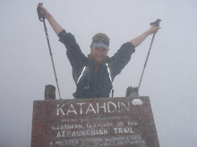
Mountains of Maine

Rocko and I on top of Baldplate Mtn, 3,662 ft


Bigelow Mtn, Avery Peak, 3,850 ft. Philly spent a rainy night in the watchtower.


Bigelow Mtn the following day, still in the clouds.


Moxie Bald Mtn, 2629 ft


A view of Mt Katahdin 5,268 ft from Rainbow ledges.

Mountains of New Hampshire

Shadow Cast on top of Mt Lincoln, 5,089 ft


Me on Top of South Kinsman, 4,358 ft


South Twin Mtn, 4,902 ft


Mt Webster, 3,910 ft


Mt. Madison 5,363 ft.

Blown Away

Rocko and I left Stratton together with a slightly sketchy ride. As we were walking to the post office another hiker with a car asked us if we were heading back to the trail. We said yes, but we had to go to the post office first. When we left the post office he was waiting in the parking lot and again offered a ride. He was a nice older section hiker, we were just weirded out that he had been waiting in the post office parking lot for us. I guess that you could also consider it very nice since he was going out of his way to give us a ride.
That night it had rained heavily, but the forecast was for the weather to clear. It was very cloudy and windy that day, although the wind did seem to be blowing the clouds away, slowly. I had just planned on getting to the first lean-to that night so when we got there for lunch and pushed on, all the extra miles put us ahead of schedule. We went over the Bigelows which most people were saying was the last really hard stretch until Katahdin. As we hiked over the ridge we were almost blown away, literally. It was possibly the windiest day on the hike. Several times I was knocked over a step or two, and once I was blown over. However, we had views, we just did not stand around too long enjoying them. We made it over the main ridge to Safford Notch Campsite for the night. We arrived late and the tentsites left were not the best. I was unable to set up my tent and I had to cowboy camp, or sleep under the stars. It was the coldest night for me in months and I was very glad I had my warm sleeping bag.
The next day Rocko and I decided to hike 22 miles. This would put us at a shelter with a gorgeous view of a lake, and right next to a sport camp where we could get pancakes in the morning. The terrain was nice and easy, for a change. We passed the 2,000 mile mark. At the next road crossing someone had spray painted "2,000 mi" in the road. After taking pictures someone in a camper drove by. I thought, stop and give us soda. He stopped right next to the sign and asked us how far we had come. We replied, "2,000 miles. You can see the sign in the road." He asked us several other questions, but did not look at the sign or give us any soda. We continued on and arrived at the lean-to around 6. We signed up for our 12 pancake breakfast in the morning and enjoyed dinner on the lake watching the sunset.
The following morning we enjoyed our 12 patriotic pancakes. They were red, white and blue from raspberries, apples and blueberries, and were absolutely amazing. As usual I left full, but nowhere near stuffed. Rocko took 4 for the road. Now, on to the crossing of the Kennebec river. The official trail is the ferry. The Maine Appalachian Trail Club (MATC) hires someone to run a canoe ferry across the river. It is a wide crossing with a variable flow dam upstream, which makes it the most dangerous crossing on the trail. We arrived soon after the ferry opened for the day and Rocko paddled while I took pictures. Later on that day Rocko's knee started bothering her and then she broke her toe. Instead of pushing on she decided to stop for the day, then get a ride and meet me in Monson. That way she could let her knee rest and still finish with me. I pushed on and hiked with Rusty Rat and Meat Hook, a father and son team from Nova Scotia.
Since I was ten miles ahead of schedule at that point I decided to hike into Monson the next day and meet up with Filadelfia who was waiting for me. Rocko also made it to town at the same time. On the way into Monson there is a blue-blaze trail that elimnates the need to hitch into town and skips 3.3 miles of trail. I took this trail to cut a 22 miles day into a 21 mile day. Then I got a ride into town which shortened the day by another 1.5 miles. So for those of you scoring at home, I did not hike the entire 2,176 miles of trail. With the amount I cut off here and in other places, I only hiked about 2,172. Please do not report me to the Appalchian Trail Club which certifies thru-hikers. Although since they give out 2,000 miler patches, I think I am OK.
In Monson that night I went out to the AYCE fish fry. In retrospect, not a great idea. I have not had that much fried food in a long time, and Shaw's, where I was staying has a famous AYCE breakfast. My stomach told me over the next couple of days that that much fried food is not good. I was also only able to get one extra plate. Oh well.